
Thank you for supporting this site ❤️
Make a donation
Make a donation
Combat topographic map
Click on the map to display elevation.
Thank you for supporting this site ❤️
Make a donation
Make a donation
About this map
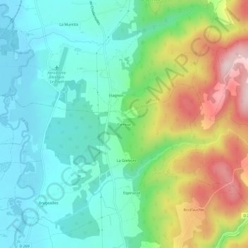
Name: Combat topographic map, elevation, terrain.
Average elevation: 632 m
Minimum elevation: 526 m
Maximum elevation: 856 m
Thank you for supporting this site ❤️
Make a donation
Make a donation
Other topographic maps
Click on a map to view its topography, its elevation and its terrain.
Chadernolles
France > Auvergne-Rhône-Alpes > Puy-de-Dôme > Marsac-en-Livradois
Average elevation: 612 m
Le Bostfaucher
France > Auvergne-Rhône-Alpes > Puy-de-Dôme > Marsac-en-Livradois
Average elevation: 693 m
Thank you for supporting this site ❤️
Make a donation
Make a donation
Les Issards
France > Auvergne-Rhône-Alpes > Puy-de-Dôme > Marsac-en-Livradois
Average elevation: 610 m