
Thank you for supporting this site ❤️
Make a donation
Make a donation
White Springs topographic map
Click on the map to display elevation.
Thank you for supporting this site ❤️
Make a donation
Make a donation
About this map
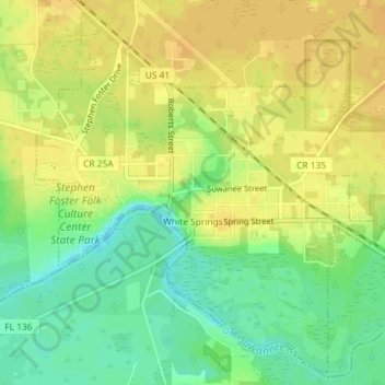
Name: White Springs topographic map, elevation, terrain.
Location: White Springs, Hamilton County, Florida, United States (30.31760 -82.77367 30.34673 -82.73759)
Average elevation: 31 m
Minimum elevation: 15 m
Maximum elevation: 41 m
Thank you for supporting this site ❤️
Make a donation
Make a donation
Other topographic maps
Click on a map to view its topography, its elevation and its terrain.