
Thank you for supporting this site ❤️
Make a donation
Make a donation
Marale topographic map
Click on the map to display elevation.
Thank you for supporting this site ❤️
Make a donation
Make a donation
About this map
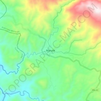
Name: Marale topographic map, elevation, terrain.
Location: Marale, Francisco Morazán, Honduras (14.85345 -87.21168 14.93345 -87.13168)
Average elevation: 814 m
Minimum elevation: 438 m
Maximum elevation: 1,592 m
Thank you for supporting this site ❤️
Make a donation
Make a donation