
Thank you for supporting this site ❤️
Make a donation
Make a donation
Heung Chung topographic map
Click on the map to display elevation.
Thank you for supporting this site ❤️
Make a donation
Make a donation
About this map
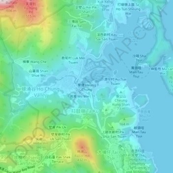
Name: Heung Chung topographic map, elevation, terrain.
Average elevation: 110 m
Minimum elevation: -5 m
Maximum elevation: 570 m
Thank you for supporting this site ❤️
Make a donation
Make a donation
Other topographic maps
Click on a map to view its topography, its elevation and its terrain.
Tseung Kwan O Waterfront Park
China > Hong Kong > Sai Kung District > Tseung Kwan O
Average elevation: 34 m