
Thank you for supporting this site ❤️
Make a donation
Make a donation
Magahis topographic map
Click on the map to display elevation.
Thank you for supporting this site ❤️
Make a donation
Make a donation
About this map
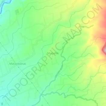
Name: Magahis topographic map, elevation, terrain.
Location: Magahis, Batangas, Calabarzon, Philippines (14.02337 120.73308 14.06337 120.77308)
Average elevation: 134 m
Minimum elevation: 49 m
Maximum elevation: 285 m
Thank you for supporting this site ❤️
Make a donation
Make a donation
Other topographic maps
Click on a map to view its topography, its elevation and its terrain.
Thank you for supporting this site ❤️
Make a donation
Make a donation
Mataasnakahoy
It has 16 barangays and its total land area is 22.10 square kilometers (8.53 sq mi). It is bounded by Balete and Lipa City with Taal Lake on its western edge. The town is known for its cool climate due to its high elevation of 379 meters (1,243 ft).
Average elevation: 222 m
Thank you for supporting this site ❤️
Make a donation
Make a donation
Dagat-Dagatan
Philippines > Batangas > Batangas City > Sirang Lupa > Sitio Kanluran
Average elevation: 30 m
Thank you for supporting this site ❤️
Make a donation
Make a donation
Thank you for supporting this site ❤️
Make a donation
Make a donation
Thank you for supporting this site ❤️
Make a donation
Make a donation
Thank you for supporting this site ❤️
Make a donation
Make a donation
Thank you for supporting this site ❤️
Make a donation
Make a donation
Thank you for supporting this site ❤️
Make a donation
Make a donation
Thank you for supporting this site ❤️
Make a donation
Make a donation
Thank you for supporting this site ❤️
Make a donation
Make a donation
Thank you for supporting this site ❤️
Make a donation
Make a donation
Thank you for supporting this site ❤️
Make a donation
Make a donation
Thank you for supporting this site ❤️
Make a donation
Make a donation