
Cité Lignères topographic map
Interactive map
Click on the map to display elevation.
About this map
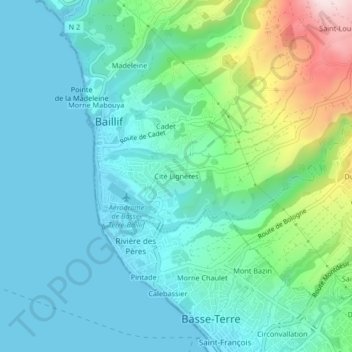
Name: Cité Lignères topographic map, elevation, terrain.
Average elevation: 92 m
Minimum elevation: 0 m
Maximum elevation: 425 m
Other topographic maps
Click on a map to view its topography, its elevation and its terrain.
Cadet
France > Guadeloupe > Baillif
Cadet, Baillif, Basse-Terre, Guadeloupe, 97123, France
Average elevation: 107 m
Plessis
France > Guadeloupe > Baillif
Plessis, Baillif, Basse-Terre, Guadeloupe, 97123, France
Average elevation: 195 m