Hanmer Springs topographic map
Click on the map to display elevation.
About this map

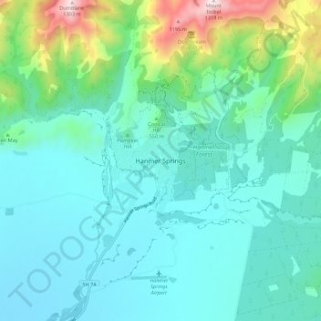
Name: Hanmer Springs topographic map, elevation, terrain.
Average elevation: 397 m
Minimum elevation: 324 m
Maximum elevation: 677 m
The Jacks Pass – Clarence River – Jollies Pass Loop is a 25 kilometer loop which is not technically challenging however it takes between two to four hours to complete. It can be ridden in either direction: West over Jacks Pass (869m) or East over Jollies Pass (850m). As the entire ride is at high elevation (700 meters above sea level) it is subject to extreme and sudden changes in the weather which have caught riders out who were not prepared.
Other topographic maps
Click on a map to view its topography, its elevation and its terrain.

Mount Lyford
New Zealand > Canterbury > Hurunui District
Mount Lyford, Hurunui District, Canterbury, New Zealand
Average elevation: 1,242 m

Leithfield
New Zealand > Canterbury > Hurunui District
Leithfield, Hurunui District, Canterbury, 7481, New Zealand
Average elevation: 19 m

Waiau
New Zealand > Canterbury > Hurunui District
Waiau, Hurunui District, Canterbury, 7332, New Zealand
Average elevation: 167 m

Mount Horrible
New Zealand > Canterbury > Hurunui District
Mount Horrible, Hurunui District, Canterbury, New Zealand
Average elevation: 1,363 m

Boyle Village
New Zealand > Canterbury > Hurunui District
Boyle Village, Hurunui District, Canterbury, New Zealand
Average elevation: 816 m

Amberley
New Zealand > Canterbury > Hurunui District
Amberley, Hurunui District, Canterbury, 7441, New Zealand
Average elevation: 55 m

Culverden
New Zealand > Canterbury > Hurunui District
Culverden, Hurunui District, Canterbury, 7345, New Zealand
Average elevation: 183 m

Conical Hill
New Zealand > Canterbury > Hurunui District > Hanmer Springs
Conical Hill, Hanmer Springs, Hurunui District, Canterbury, 7334, New Zealand
Average elevation: 457 m

Leithfield Beach
New Zealand > Canterbury > Hurunui District
Leithfield Beach, Hurunui District, Canterbury, 7481, New Zealand
Average elevation: 6 m

Waipara River
New Zealand > Canterbury > Hurunui District > Waipara
Waipara River, Waipara, Hurunui District, Canterbury, 7441, New Zealand
Average elevation: 108 m

Waipara
New Zealand > Canterbury > Hurunui District
Waipara, Hurunui District, Canterbury, New Zealand
Average elevation: 74 m

Cheviot
New Zealand > Canterbury > Hurunui District
Cheviot, Hurunui District, Canterbury, 7310, New Zealand
Average elevation: 93 m