Porirua topographic map
Interactive map
Click on the map to display elevation.
About this map
![Porirua topographic map, elevation, terrain](/pub/maps/node/qqnx/m2c8nnh/thumbnail.jpg)
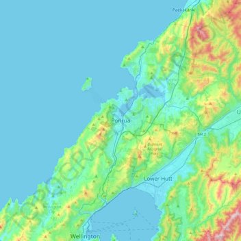
Name: Porirua topographic map, elevation, terrain.
Location: Porirua, Porirua City, Wellington, 5022, New Zealand (-41.29542 174.67978 -40.97542 174.99978)
Average elevation: 115 m
Minimum elevation: 0 m
Maximum elevation: 785 m
Other topographic maps
Click on a map to view its topography, its elevation and its terrain.
![Judgeford topographic map, elevation, terrain](/pub/maps/relation/lrr/wv3n51/icon.jpg)
Judgeford
New Zealand > Wellington > Porirua City > Porirua
Judgeford, Porirua, Porirua City, Wellington, New Zealand
Average elevation: 170 m
![Colonial Knob topographic map, elevation, terrain](/pub/maps/node/fn1h/kmbtfz4/icon.jpg)
Colonial Knob
New Zealand > Wellington > Porirua City > Porirua
Colonial Knob, Porirua, Porirua City, Wellington, 5028, New Zealand
Average elevation: 275 m
![Belmont Regional Park topographic map, elevation, terrain](/pub/maps/relation/f614/kbkrgt/icon.jpg)
Belmont Regional Park
New Zealand > Wellington > Porirua City > Porirua
Belmont Regional Park, Porirua, Porirua City, Wellington, New Zealand
Average elevation: 186 m