
Thank you for supporting this site ❤️
Make a donation
Make a donation
Hotan County topographic map
Click on the map to display elevation.
Thank you for supporting this site ❤️
Make a donation
Make a donation
About this map
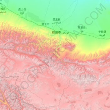
Name: Hotan County topographic map, elevation, terrain.
Location: Hotan County, Hotan Prefecture, Xinjiang, 848000, China (34.33406 78.00292 38.08494 80.58005)
Average elevation: 3,661 m
Minimum elevation: 1,200 m
Maximum elevation: 7,357 m
Thank you for supporting this site ❤️
Make a donation
Make a donation
Other topographic maps
Click on a map to view its topography, its elevation and its terrain.