
Thank you for supporting this site ❤️
Make a donation
Make a donation
Matas topographic map
Click on the map to display elevation.
Thank you for supporting this site ❤️
Make a donation
Make a donation
About this map
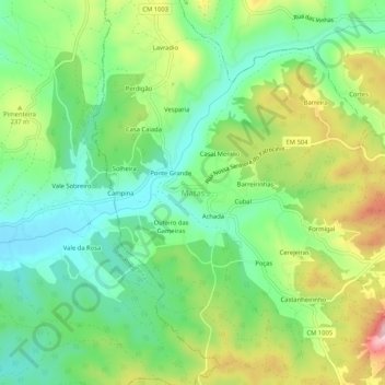
Name: Matas topographic map, elevation, terrain.
Location: Matas, Ourém, Santarém, 2420-115, Portugal (39.72297 -8.68778 39.76297 -8.64778)
Average elevation: 197 m
Minimum elevation: 113 m
Maximum elevation: 341 m
Thank you for supporting this site ❤️
Make a donation
Make a donation
Other topographic maps
Click on a map to view its topography, its elevation and its terrain.
Thank you for supporting this site ❤️
Make a donation
Make a donation
Thank you for supporting this site ❤️
Make a donation
Make a donation