
Thank you for supporting this site ❤️
Make a donation
Make a donation
Northampton County topographic map
Click on the map to display elevation.
Thank you for supporting this site ❤️
Make a donation
Make a donation
About this map
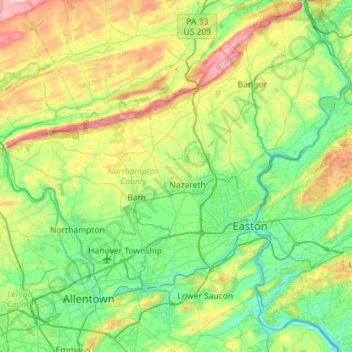
Name: Northampton County topographic map, elevation, terrain.
Location: Northampton County, Pennsylvania, United States (40.53677 -75.60868 40.96854 -75.05064)
Average elevation: 184 m
Minimum elevation: 32 m
Maximum elevation: 596 m
Thank you for supporting this site ❤️
Make a donation
Make a donation
Other topographic maps
Click on a map to view its topography, its elevation and its terrain.