
Make a donation
Hobart topographic map
Click on the map to display elevation.
Make a donation
Hobart
Although Hobart itself rarely receives snow during the winter due to the foehn effect created by the Central Highlands (the city's geographic position causes a rainshadow), the adjacent Kunanyi/Mount Wellington is frequently seen with a snowcap throughout the year including in summer. During the 20th century, the city itself has received snowfalls at sea level on average only once every 5 years; however, outer suburbs lying higher on the slopes of Mount Wellington receive snow more often, owing to the more exposed position coupled with them resting at higher altitude. These snow-bearing winds often carry on through Tasmania and Victoria to the Snowy Mountains in Victoria and southern New South Wales.
Make a donation
About this map
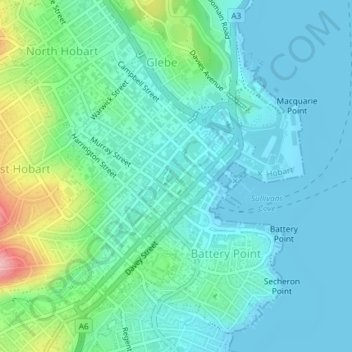
Name: Hobart topographic map, elevation, terrain.
Location: Hobart, City of Hobart, Tasmania, 7000, Australia (-42.89164 147.31561 -42.87305 147.34150)
Average elevation: 31 m
Minimum elevation: -2 m
Maximum elevation: 147 m
Make a donation
Other topographic maps
Click on a map to view its topography, its elevation and its terrain.
Make a donation
Make a donation
Make a donation