
Thank you for supporting this site ❤️
Make a donation
Make a donation
Ōakura River topographic map
Click on the map to display elevation.
Thank you for supporting this site ❤️
Make a donation
Make a donation
About this map
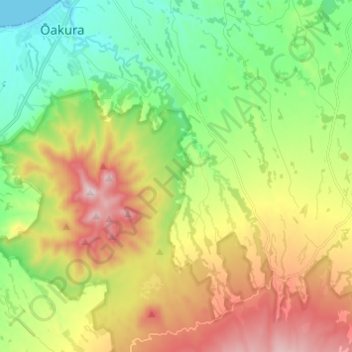
Name: Ōakura River topographic map, elevation, terrain.
Location: Ōakura River, New Plymouth District, Taranaki, New Zealand (-39.22809 173.95522 -39.10995 174.01325)
Average elevation: 301 m
Minimum elevation: 0 m
Maximum elevation: 1,168 m
New Plymouth District trails, hiking, mountain biking, running and outdoor activities
Thank you for supporting this site ❤️
Make a donation
Make a donation
Other topographic maps
Click on a map to view its topography, its elevation and its terrain.
Thank you for supporting this site ❤️
Make a donation
Make a donation
Thank you for supporting this site ❤️
Make a donation
Make a donation
Thank you for supporting this site ❤️
Make a donation
Make a donation