
Seydisfjordur topographic map
Interactive map
Click on the map to display elevation.
Seydisfjordur
A road over Fjarðarheiði mountain pass (elevation 600 m or 2,000 ft) connects Seyðisfjörður to the rest of Iceland; 27 kilometres (17 miles) to the ring road and Egilsstaðir. Seyðisfjörður is surrounded by mountains with the most prominent Mt. Bjólfur to the west (1085 m) and Strandartindur (1010 m) to the east. The fjord itself is accessible on each side from the town, by following the main road that leads through the town. Further out the fjord is fairly remote but rich with natural interests including puffin colonies and ruins of former activity such as nearby Vestdalseyri [ˈvɛstˌtalsˌeiːrɪ], from where the local church was transported.
About this map
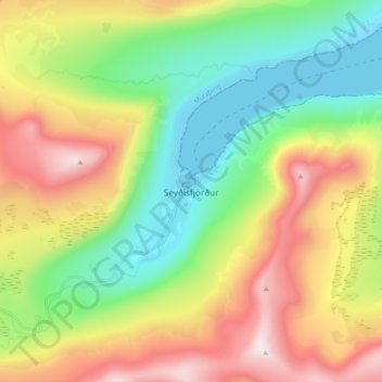
Name: Seydisfjordur topographic map, elevation, terrain.
Location: Seydisfjordur, Múlaþing, Eastern Region, 710, Iceland (65.21985 -14.04490 65.29985 -13.96490)
Average elevation: 443 m
Minimum elevation: -1 m
Maximum elevation: 1,129 m