
Thank you for supporting this site ❤️
Make a donation
Make a donation
Ntunda topographic map
Click on the map to display elevation.
Thank you for supporting this site ❤️
Make a donation
Make a donation
About this map
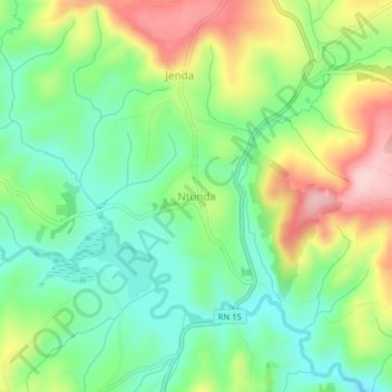
Name: Ntunda topographic map, elevation, terrain.
Location: Ntunda, Gitega, Burundi (-3.32870 29.89597 -3.28870 29.93597)
Average elevation: 1,547 m
Minimum elevation: 1,461 m
Maximum elevation: 1,686 m
Thank you for supporting this site ❤️
Make a donation
Make a donation