
Make a donation
Fazilka District topographic map
Click on the map to display elevation.
Make a donation
About this map
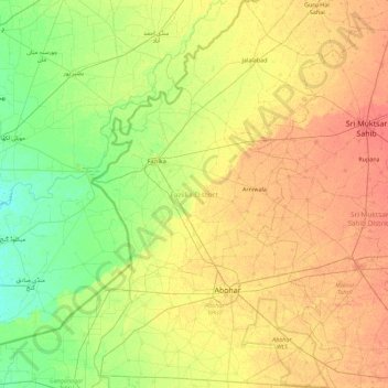
Name: Fazilka District topographic map, elevation, terrain.
Location: Fazilka District, Punjab, India (29.94699 73.87983 30.72451 74.46289)
Average elevation: 184 m
Minimum elevation: 167 m
Maximum elevation: 203 m
Make a donation
Other topographic maps
Click on a map to view its topography, its elevation and its terrain.
Make a donation
Make a donation
Bathinda
India > Punjab > Bathinda Tahsil
Bathinda is in the northwestern region of India and is a part of the Indo-Gangetic alluvial plains. The exact cartographic co-ordinates of Bathinda are 30°12′N 74°57′E / 30.20°N 74.95°E / 30.20; 74.95. It has an average elevation of 201 metres (660 ft).
Average elevation: 208 m
Make a donation
Hoshiarpur
India > Punjab > Hoshiarpur Tahsil
Hoshiarpur has an average elevation of 296 metres (971 ft). Hoshiarpur district is located in the north-east part of the Indian state of Punjab. It falls in the Jalandhar Revenue Division and is situated in the Bist Doab portion of the Doaba region. Hoshiarpur shares a boundary with Kangra district, and Una…
Average elevation: 327 m
Make a donation
Make a donation
Make a donation
Make a donation
Make a donation
Khamanon
India > Punjab > Khamanon Tahsil
Khamanon is located at 30°49′N 76°21′E / 30.82°N 76.35°E / 30.82; 76.35. It has an average elevation of 254 metres (833 feet).
Average elevation: 274 m
Make a donation
Mukerian
India > Punjab > Mukerian Tahsil
Mukerian is located at 31°57′N 75°37′E / 31.95°N 75.62°E / 31.95; 75.62. It has an average elevation of 245 metres (804 ft).
Average elevation: 258 m
Make a donation
Make a donation
Make a donation
Make a donation
Rajpura
India > Punjab > Rajpura Tahsil
Rajpura is located at 30°29′N 76°36′E / 30.48°N 76.6°E / 30.48; 76.6. It has an average elevation of 259 metres (849 feet). Rajpura is situated nearly 38 km south west of Chandigarh, the capital city of Punjab. Besides being an important industrial town of Punjab, it also has historical importance.
Average elevation: 270 m
Patiala
India > Punjab > Patiala Tahsil > Patiala
Patiala is located at 30°19′N 76°24′E / 30.32°N 76.40°E / 30.32; 76.40. It has an average elevation of 250 metres (820 feet). During the short existence of PEPSU, Patiala served as its capital city.
Average elevation: 255 m
Make a donation
Kartarpur
India > Punjab > Jalandhar II Tahsil > Kartarpur
Kartarpur is located at 31°26′N 75°30′E / 31.44°N 75.5°E / 31.44; 75.5. It has an average elevation of 228 metres (748 feet). It is situated at a distance of 15 km from Jalandhar towards Amritsar on G.T. Road (National Highway 1).
Average elevation: 236 m
Make a donation
Make a donation
Make a donation