
Mount Buller topographic map
Interactive map
Click on the map to display elevation.
Mount Buller
Due to its far south-western location in the alpine region, Mount Buller is more susceptible to cold airmasses which allow it to record some of the lowest maximum temperatures and daytime readings in the country, despite being considerably lower in elevation than other mountain sites to the north-east. On 5 September 1995, a maximum temperature of just −6.2 °C (20.8 °F) was registered at Mount Buller; the same day at Thredbo Top Station saw a maximum of −6.0 °C (21.2 °F), some 250 metres (820 ft) higher than Buller. On 3 February 2023, at the height of summer, Mount Buller reached a top of just 0.9 °C (33.6 °F).
About this map
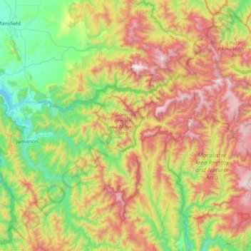
Name: Mount Buller topographic map, elevation, terrain.
Average elevation: 824 m
Minimum elevation: 256 m
Maximum elevation: 1,779 m
Other topographic maps
Click on a map to view its topography, its elevation and its terrain.
Dandenong Ranges
Australia > Victoria > Melbourne
The topography consists of a series of ridges dissected by deeply cut streams. Sheltered gullies in the south of the range are home to temperate rain forest, fern gullies and Mountain Ash forest Eucalyptus regnans, whereas the drier ridges and exposed northern slopes are covered by dry sclerophyll forest of…
Average elevation: 456 m
Melbourne
Australia > Victoria > Melbourne
Melbourne is also prone to isolated convective showers forming when a cold pool crosses the state, especially if there is considerable daytime heating. These showers are often heavy and can include hail, squalls, and significant drops in temperature, but they often pass through very quickly with a rapid…
Average elevation: 49 m