
Maiern topographic map
Interactive map
Click on the map to display elevation.
About this map
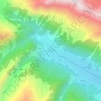
Name: Maiern topographic map, elevation, terrain.
Location: Maiern, Ratschings, Wipptal, Bozen, Trentino-Südtirol, Italien (46.90292 11.26059 46.94292 11.30059)
Average elevation: 1,778 m
Minimum elevation: 1,313 m
Maximum elevation: 2,627 m
Other topographic maps
Click on a map to view its topography, its elevation and its terrain.
Plan
Italien > Trentino-Südtirol > Bozen > Ratschings > Plan
Plan, Ratschings, Wipptal, Bozen, Trentino-Südtirol, Italien
Average elevation: 1,602 m