
Tempelhof-Schöneberg topographic map
Interactive map
Click on the map to display elevation.
About this map
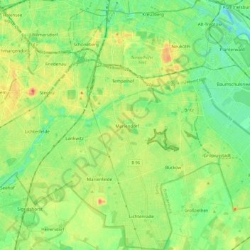
Name: Tempelhof-Schöneberg topographic map, elevation, terrain.
Location: Tempelhof-Schöneberg, Berlin, Germany (52.37614 13.31999 52.50493 13.42746)
Average elevation: 45 m
Minimum elevation: 27 m
Maximum elevation: 72 m
Other topographic maps
Click on a map to view its topography, its elevation and its terrain.