
Make a donation
Laconia Regional Unit topographic map
Click on the map to display elevation.
Make a donation
About this map
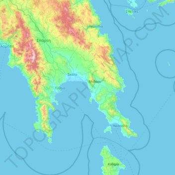
Name: Laconia Regional Unit topographic map, elevation, terrain.
Average elevation: 199 m
Minimum elevation: -2 m
Maximum elevation: 2,345 m
Make a donation
Other topographic maps
Click on a map to view its topography, its elevation and its terrain.
Patras
Greece > Peloponnese, Western Greece and the Ionian > Achaia Regional Unit
A central feature of the urban geography of Patras is its division into upper and lower sections. This is the result of an interplay between natural geography and human settlement patterns; the lower section of the city (Kato Poli), which includes the 19th-century urban core and the port, is adjacent to the…
Average elevation: 283 m
Nafplio
Greece > Peloponnese, Western Greece and the Ionian > Argolis Regional Unit > Municipal Unit of Nafplio
Average elevation: 36 m
Kouroutas
Greece > Peloponnese, Western Greece and the Ionian > Elis Regional Unit > Amaliada Municipal Unit
Average elevation: 5 m
Corinth
Greece > Peloponnese, Western Greece and the Ionian > Corinthia Regional Unit
Average elevation: 185 m
Make a donation