
Thank you for supporting this site ❤️
Make a donation
Make a donation
Freiensteinau topographic map
Click on the map to display elevation.
Thank you for supporting this site ❤️
Make a donation
Make a donation
About this map
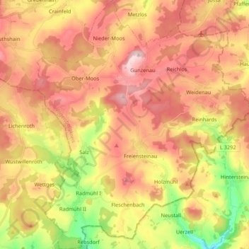
Name: Freiensteinau topographic map, elevation, terrain.
Location: Freiensteinau, Vogelsbergkreis, Hesse, 36399, Germany (50.38550 9.33483 50.48978 9.47866)
Average elevation: 443 m
Minimum elevation: 294 m
Maximum elevation: 556 m
Thank you for supporting this site ❤️
Make a donation
Make a donation
Other topographic maps
Click on a map to view its topography, its elevation and its terrain.