Western Sahara topographic map
Interactive map
Click on the map to display elevation.
About this map
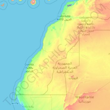
Name: Western Sahara topographic map, elevation, terrain.
Location: Western Sahara, Morocco (20.66725 -17.31902 27.67063 -8.66625)
Average elevation: 179 m
Minimum elevation: -60 m
Maximum elevation: 1,777 m
Other topographic maps
Click on a map to view its topography, its elevation and its terrain.
Casablanca
Morocco > préfecture d'arrondissements de Casablanca-Anfa عمالة مقاطعات الدار البيضاء أنفا
Average elevation: 66 m
Taounate
Morocco > pachalik du Taounate
The area surrounding Taounate is generally mountainous, and cereals (mostly wheat) and cattle are intensively raised at lower elevations. Fruits (including figs, olives, cherries, apples, and pears) are grown in the well-watered mountain valleys. Higher elevations are covered with commercially exploited cedars…
Average elevation: 375 m
Fez
Morocco > Pachalik du Fes باشوية فاس
The last major change to Fez's topography before the 20th century was made during the reign of Moulay Hassan I (1873-1894), who finally connected Fes Jdid and Fes el-Bali by building a walled corridor between them. New gardens and summer palaces, used by the royals and the capital's high society, were built…
Average elevation: 432 m
Marrakesh
Morocco > Pachalik de Marrakech
By road, Marrakesh is 580 kilometres (360 mi) southwest of Tangier, 327 kilometres (203 mi) southwest of the Moroccan capital of Rabat, 239 kilometres (149 mi) southwest of Casablanca, 196 kilometres (122 mi) southwest of Beni Mellal, 177 kilometres (110 mi) east of Essaouira, and 246 kilometres (153 mi)…
Average elevation: 464 m
Chefchaouen
The province of Chefchaouen has a Mediterranean climate characterized by rainy and cool winters from October to April, and dry and hot summers from May to September. The average annual rainfall is around 880 mm (35 in), variable with altitude and proximity to the coast. (Rainfall could reach 1,400–2,000 mm…
Average elevation: 619 m
Ifrane
Morocco > Pachalik d'Ifrane ⵜⴰⴱⴰⵛⴰⵏⵜ ⵏ ⵉⴼⵔⴰⵏ باشوية إفران > Ifrane
Ifrane (Berber: ⵉⴼⵔⴰⵏ; Arabic: إفران) is a city in the Middle Atlas region of northern Morocco (population 14,659 as of November 2014). The capital of Ifrane Province in the region of Fès-Meknès, Ifrane is located at an elevation of 1,665 m (5,463 ft). In the regional Tamazight language, "ifran" means caves.
Average elevation: 1,668 m
arrondissement de Guéliz كليز
Morocco > Pachalik de Marrakech > arrondissement de Guéliz كليز
Average elevation: 441 m