North-West District topographic map
Interactive map
Click on the map to display elevation.
North-West District topographic map, elevation, terrain
North-West District
The region has an average elevation of around 915 m (3,002 ft) above the mean sea level. The vegetation type is Savannah, with tall grasses, bushes and trees. The annual precipitation is around 650 mm (26 in), most of which is received during the summer season from November to May.
About this map
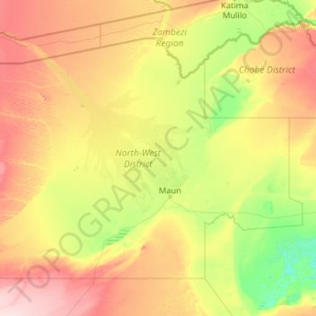
Name: North-West District topographic map, elevation, terrain.
Location: North-West District, Botswana (-21.00318 20.99886 -18.00076 25.17840)
Average elevation: 979 m
Minimum elevation: 902 m
Maximum elevation: 1,228 m
Other topographic maps
Click on a map to view its topography, its elevation and its terrain.
Southern District
In the south, Southern borders the North West Province of South Africa. Domestically, it borders South-East District in east, Kweneng District in north, Kgalagadi District and south west. Southern District is traversed by the northwesterly line of equal latitude and longitude. Most part of Botswana has…
Average elevation: 1,139 m
Gaborone
Botswana > South-East District
Gaborone is situated at 24°39′29″S 25°54′44″E / 24.65806°S 25.91222°E / -24.65806; 25.91222 between Kgale and Oodi Hills, on the Notwane River in the south-eastern corner of Botswana, and 15 kilometres (9.3 mi) from the South African border The city lies at an elevation of 1,010 metres…
Average elevation: 1,032 m