
Thank you for supporting this site ❤️
Make a donation
Make a donation
Toowoomba Regional topographic map
Click on the map to display elevation.
Thank you for supporting this site ❤️
Make a donation
Make a donation
About this map
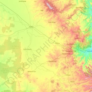
Name: Toowoomba Regional topographic map, elevation, terrain.
Location: Toowoomba Regional, Queensland, Australia (-28.19234 150.70267 -26.76681 152.26999)
Average elevation: 421 m
Minimum elevation: 91 m
Maximum elevation: 1,116 m
Thank you for supporting this site ❤️
Make a donation
Make a donation
Other topographic maps
Click on a map to view its topography, its elevation and its terrain.
Thank you for supporting this site ❤️
Make a donation
Make a donation
Torres Strait
Several clusters of islands lie in the Strait, collectively called the Torres Strait Islands. There are at least 274 of these islands, of which 17 have present-day permanent settlements. These islands have a variety of topographies, ecosystems and formation history. Several of those closest to the New Guinea…
Average elevation: 0 m
Thank you for supporting this site ❤️
Make a donation
Make a donation
Thank you for supporting this site ❤️
Make a donation
Make a donation
Thank you for supporting this site ❤️
Make a donation
Make a donation
Thank you for supporting this site ❤️
Make a donation
Make a donation
Koala Park Bushland Conservation Reserve
Australia > Queensland > Sunshine Coast Regional > Nambour
Average elevation: 35 m
Thank you for supporting this site ❤️
Make a donation
Make a donation
Thank you for supporting this site ❤️
Make a donation
Make a donation