
Surrey topographic map
Interactive map
Click on the map to display elevation.
About this map
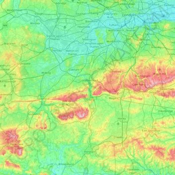
Name: Surrey topographic map, elevation, terrain.
Location: Surrey, England, Vereinigtes Königreich (51.07150 -0.84893 51.47156 0.05822)
Average elevation: 69 m
Minimum elevation: -1 m
Maximum elevation: 289 m
Other topographic maps
Click on a map to view its topography, its elevation and its terrain.
Camberley
Vereinigtes Königreich > England > Surrey > Surrey Heath
Camberley, Surrey Heath, Surrey, England, GU15 3SA, Vereinigtes Königreich
Average elevation: 88 m
Lower Kingswood
Vereinigtes Königreich > England > Surrey > Reigate and Banstead
Lower Kingswood, Reigate and Banstead, Surrey, England, KT20 7AA, Vereinigtes Königreich
Average elevation: 170 m