
Thank you for supporting this site ❤️
Make a donation
Make a donation
Waiau topographic map
Click on the map to display elevation.
Thank you for supporting this site ❤️
Make a donation
Make a donation
About this map
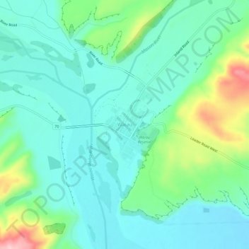
Name: Waiau topographic map, elevation, terrain.
Location: Waiau, Hurunui District, Canterbury, 7332, New Zealand (-42.67510 173.02235 -42.63510 173.06235)
Average elevation: 167 m
Minimum elevation: 116 m
Maximum elevation: 324 m
Hurunui District trails, hiking, mountain biking, running and outdoor activities
Thank you for supporting this site ❤️
Make a donation
Make a donation