
Thank you for supporting this site ❤️
Make a donation
Make a donation
Patean topographic map
Click on the map to display elevation.
Thank you for supporting this site ❤️
Make a donation
Make a donation
About this map
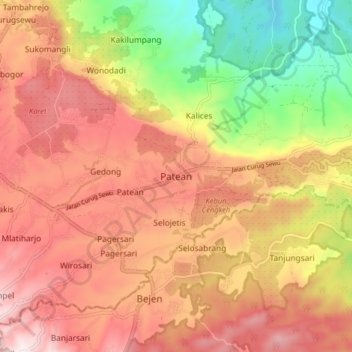
Name: Patean topographic map, elevation, terrain.
Location: Patean, Kendal, Central Java, Java, Indonesia (-7.13079 110.05075 -7.05079 110.13075)
Average elevation: 422 m
Minimum elevation: 54 m
Maximum elevation: 699 m
Thank you for supporting this site ❤️
Make a donation
Make a donation
Other topographic maps
Click on a map to view its topography, its elevation and its terrain.
Taman Alun-Alun Kaliwungu
Indonesia > Central Java > Kendal > Kendal > Sikopek Kulon
Average elevation: 15 m
Taman Kantor Kecamatan Kaliwungu
Indonesia > Central Java > Kendal > Kendal > Sikopek Kulon
Average elevation: 8 m