
Washington County topographic map
Interactive map
Click on the map to display elevation.
About this map
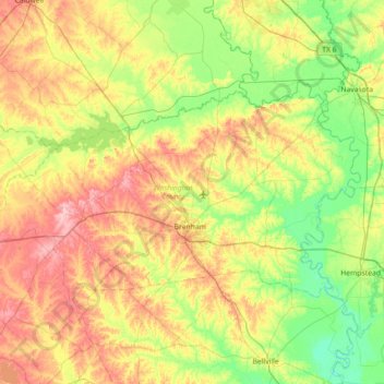
Name: Washington County topographic map, elevation, terrain.
Location: Washington County, Texas, United States of America (30.04437 -96.79445 30.40035 -96.08137)
Average elevation: 87 m
Minimum elevation: 33 m
Maximum elevation: 171 m
Other topographic maps
Click on a map to view its topography, its elevation and its terrain.
Lake Medina Highlands
United States of America > Texas > Lakehills > Lake Medina Highlands
Average elevation: 344 m