
Udhampur topographic map
Interactive map
Click on the map to display elevation.
About this map
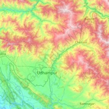
Name: Udhampur topographic map, elevation, terrain.
Location: Udhampur, Udhampur District, Jammu and Kashmir, India (32.78580 74.97743 33.19356 75.25420)
Average elevation: 1,292 m
Minimum elevation: 331 m
Maximum elevation: 2,932 m
Other topographic maps
Click on a map to view its topography, its elevation and its terrain.
Siachen Glacier
Siachen Glacier, Leh District, Jammu and Kashmir, India
Average elevation: 5,448 m
South Rimo Glacier
South Rimo Glacier, Leh District, Jammu and Kashmir, India
Average elevation: 5,595 m
Anantnag
India > Jammu and Kashmir > Anantnag
Anantnag, Jammu and Kashmir, India
Average elevation: 1,785 m
Nun
Nun, Kargil District, Jammu and Kashmir, India
Average elevation: 5,988 m