
Thank you for supporting this site ❤️
Make a donation
Make a donation
Mount Somers topographic map
Click on the map to display elevation.
Thank you for supporting this site ❤️
Make a donation
Make a donation
About this map
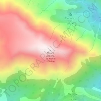
Name: Mount Somers topographic map, elevation, terrain.
Location: Mount Somers, Ashburton District, Canterbury, New Zealand (-43.61958 171.37513 -43.61948 171.37523)
Average elevation: 1,221 m
Minimum elevation: 760 m
Maximum elevation: 1,692 m
Ashburton District trails, hiking, mountain biking, running and outdoor activities
Thank you for supporting this site ❤️
Make a donation
Make a donation
Other topographic maps
Click on a map to view its topography, its elevation and its terrain.