
Thank you for supporting this site ❤️
Make a donation
Make a donation
Breungeshain topographic map
Click on the map to display elevation.
Thank you for supporting this site ❤️
Make a donation
Make a donation
About this map
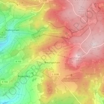
Name: Breungeshain topographic map, elevation, terrain.
Location: Breungeshain, Schotten, Vogelsbergkreis, Hesse, Germany (50.49130 9.18810 50.53430 9.27064)
Average elevation: 599 m
Minimum elevation: 386 m
Maximum elevation: 772 m
Thank you for supporting this site ❤️
Make a donation
Make a donation
Other topographic maps
Click on a map to view its topography, its elevation and its terrain.