
Make a donation
Macugnaga topographic map
Click on the map to display elevation.
Make a donation
Macugnaga
Macugnaga (Walser German: Z'Makana) is a mountain village and a comune at 1,327 metres (4,354 ft) elevation, in the province of Verbano-Cusio-Ossola, in the north of the Piedmont region of Italy.
Make a donation
About this map
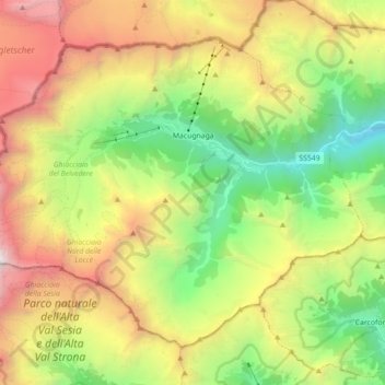
Name: Macugnaga topographic map, elevation, terrain.
Location: Macugnaga, Verbano-Cusio-Ossola, Piedmont, 28876, Italy (45.90061 7.86850 45.99942 8.04530)
Average elevation: 2,328 m
Minimum elevation: 834 m
Maximum elevation: 4,483 m
Make a donation
Other topographic maps
Click on a map to view its topography, its elevation and its terrain.
Make a donation
Mottarone
Italy > Piedmont > Verbano-Cusio-Ossola > Stresa
Mottarone is a mountain in the Western Alps of Piedmont, north-western Italy, with an elevation of 1,492 metres (4,895 ft). It is located between the provinces of Verbano-Cusio-Ossola and Novara.
Average elevation: 1,177 m
Make a donation
Make a donation
Make a donation
Giardini Botanici Villa Taranto
Italy > Piedmont > Verbano-Cusio-Ossola > Verbania
Average elevation: 210 m
Make a donation