
Sinaia topographic map
Interactive map
Click on the map to display elevation.
About this map
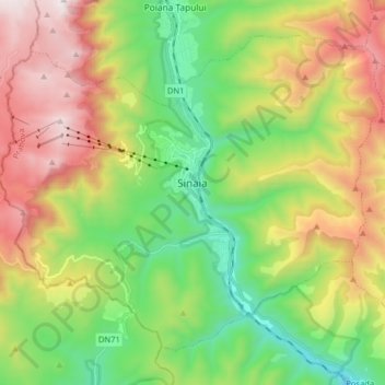
Name: Sinaia topographic map, elevation, terrain.
Location: Sinaia, Prahova, 106100, Rumänien (45.29640 25.46770 45.38861 25.62769)
Average elevation: 1,249 m
Minimum elevation: 649 m
Maximum elevation: 2,141 m
Sinaia liegt in den Südkarpaten im Tal des Flusses Prahova. Um die Kleinstadt liegt ein beliebtes Skigebiet, das Bucegi-Gebirge. Von Sinaia (767–860 m) führt eine Seilbahn bis auf eine Höhe von 2000 m, außerdem gibt es mehrere Skilifte. An der Bahnstrecke Ploiești–Brașov gelegen, halten hier sämtliche Regional-, Interregio- und Intercity-Züge von und nach Prag bzw. Wien. An der Europastraße 60 befindet sich Sinaia 44 Kilometer südlich von Brașov (Kronstadt) und 65 Kilometer nordwestlich von der Kreishauptstadt Ploiești entfernt.
Other topographic maps
Click on a map to view its topography, its elevation and its terrain.
Băile Boboci
Băile Boboci, Jugureni, Prahova, 107331, Rumänien
Average elevation: 357 m