
Thank you for supporting this site ❤️
Make a donation
Make a donation
Veldhoek topographic map
Click on the map to display elevation.
Thank you for supporting this site ❤️
Make a donation
Make a donation
About this map
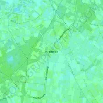
Name: Veldhoek topographic map, elevation, terrain.
Average elevation: 18 m
Minimum elevation: 14 m
Maximum elevation: 21 m
Thank you for supporting this site ❤️
Make a donation
Make a donation
Other topographic maps
Click on a map to view its topography, its elevation and its terrain.
Thank you for supporting this site ❤️
Make a donation
Make a donation
Groesbeek
Due to this, the topography is much more varied here than in other higher grounds with similar origins in the Netherlands. Finally, during the Younger Dryas stadial, large amounts of loess were deposited in the valley, making it extremely fertile, while the hills around it are composed to this day of sandy…
Average elevation: 41 m
Thank you for supporting this site ❤️
Make a donation
Make a donation
Wageningen
Topographic map of the municipality of Wageningen, July 2013 (click to enlarge)
Average elevation: 13 m
Thank you for supporting this site ❤️
Make a donation
Make a donation
Thank you for supporting this site ❤️
Make a donation
Make a donation
Thank you for supporting this site ❤️
Make a donation
Make a donation