
Almaty topographic map
Interactive map
Click on the map to display elevation.
About this map
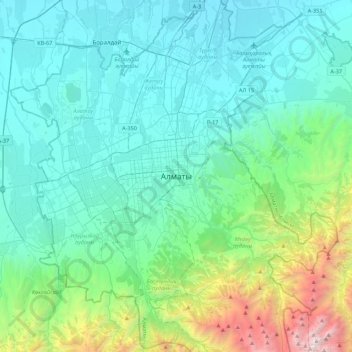
Name: Almaty topographic map, elevation, terrain.
Location: Almaty, Бостандыкский район, Almaty, 050013, Kazakhstan (43.07639 76.78573 43.39639 77.10573)
Average elevation: 1,261 m
Minimum elevation: 633 m
Maximum elevation: 4,319 m
Other topographic maps
Click on a map to view its topography, its elevation and its terrain.