
Thank you for supporting this site ❤️
Make a donation
Make a donation
Montelparo topographic map
Click on the map to display elevation.
Thank you for supporting this site ❤️
Make a donation
Make a donation
About this map
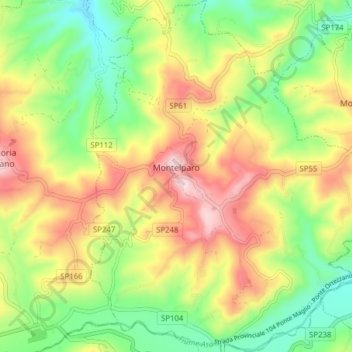
Name: Montelparo topographic map, elevation, terrain.
Location: Montelparo, Fermo, Marche, 63853, Italy (42.98798 13.51839 43.04487 13.58328)
Average elevation: 366 m
Minimum elevation: 200 m
Maximum elevation: 577 m
Thank you for supporting this site ❤️
Make a donation
Make a donation
Other topographic maps
Click on a map to view its topography, its elevation and its terrain.