
Gdansk topographic map
Interactive map
Click on the map to display elevation.
About this map
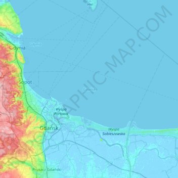
Name: Gdansk topographic map, elevation, terrain.
Location: Gdansk, Pomeranian Voivodeship, Poland (54.27492 18.42950 54.44722 18.95328)
Average elevation: 49 m
Minimum elevation: -5 m
Maximum elevation: 261 m
Other topographic maps
Click on a map to view its topography, its elevation and its terrain.
Gdynia
Poland > Pomeranian Voivodeship > Gdynia
Gdynia, Pomeranian Voivodeship, Poland
Average elevation: 51 m
Sulęczyno
Poland > Pomeranian Voivodeship > Kartuzy County > Sulęczyno
Sulęczyno, gmina Sulęczyno, Kartuzy County, Pomeranian Voivodeship, 83-320, Poland
Average elevation: 184 m
Laska
Poland > Pomeranian Voivodeship > Chojnice County > Laska
Laska, gmina Brusy, Chojnice County, Pomeranian Voivodeship, 89-608, Poland
Average elevation: 140 m
Gdynia
Poland > Pomeranian Voivodeship
Gdynia, Wejherowo County, Pomeranian Voivodeship, Poland
Average elevation: 92 m