
Okavango River topographic map
Interactive map
Click on the map to display elevation.
Okavango River
The Okavango River (formerly spelled Okovango or Okovanggo), also known as the Cubango River, is a river in southwest Africa. It is the fourth-longest river system in southern Africa, running southeastward for 1,600 km (1,000 mi). It begins at an elevation of 1,300 metres (4,300 ft) in the sandy highlands of Angola. Farther south, it forms part of the border between Angola and Namibia, and then flows into Botswana. The Okavango does not have an outlet to the sea. Instead, it discharges into the Okavango Delta or Okavango Alluvial Fan, in an endorheic basin in the Kalahari Desert.
About this map
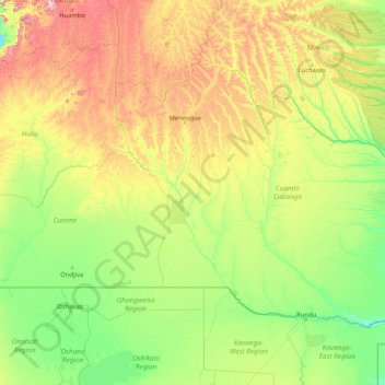
Name: Okavango River topographic map, elevation, terrain.
Location: Okavango River, Angola (-18.98829 16.08085 -12.61569 22.57846)
Average elevation: 1,261 m
Minimum elevation: 1,037 m
Maximum elevation: 2,464 m
Other topographic maps
Click on a map to view its topography, its elevation and its terrain.