
Thank you for supporting this site ❤️
Make a donation
Make a donation
Atimonan topographic map
Click on the map to display elevation.
Thank you for supporting this site ❤️
Make a donation
Make a donation
About this map
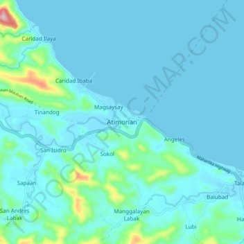
Name: Atimonan topographic map, elevation, terrain.
Location: Atimonan, Quezon, Calabarzon, 4331, Philippines (13.95894 121.88084 14.03894 121.96084)
Average elevation: 33 m
Minimum elevation: 0 m
Maximum elevation: 301 m
Thank you for supporting this site ❤️
Make a donation
Make a donation
Other topographic maps
Click on a map to view its topography, its elevation and its terrain.
Thank you for supporting this site ❤️
Make a donation
Make a donation
Thank you for supporting this site ❤️
Make a donation
Make a donation