
Huzur Tahsil topographic map
Interactive map
Click on the map to display elevation.
About this map
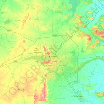
Name: Huzur Tahsil topographic map, elevation, terrain.
Location: Huzur Tahsil, Bhopal District, Madhya Pradesh, India (23.09387 77.16873 23.45794 77.62758)
Average elevation: 494 m
Minimum elevation: 430 m
Maximum elevation: 638 m
Other topographic maps
Click on a map to view its topography, its elevation and its terrain.