
Thank you for supporting this site ❤️
Make a donation
Make a donation
Qeqqata topographic map
Click on the map to display elevation.
Thank you for supporting this site ❤️
Make a donation
Make a donation
About this map
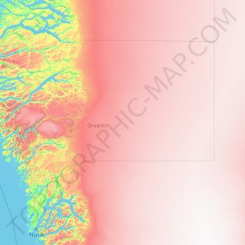
Name: Qeqqata topographic map, elevation, terrain.
Location: Qeqqata, Greenland (64.37012 -54.63986 67.77187 -44.00004)
Average elevation: 1,504 m
Minimum elevation: -6 m
Maximum elevation: 2,812 m
Thank you for supporting this site ❤️
Make a donation
Make a donation
Other topographic maps
Click on a map to view its topography, its elevation and its terrain.
Nuuk
Nuuk's sports clubs include Nuuk IL (established in 1934), B-67, and GSS Nuuk. Nuuk Stadium is a multi-purpose stadium, used mostly for football games. The stadium has a capacity of 2,000.[67] The stadium can also be used as an entertainment venue: the Scottish rock band Nazareth performed at the venue. Nuuk…
Average elevation: 76 m