
Thank you for supporting this site ❤️
Make a donation
Make a donation
Zapote topographic map
Click on the map to display elevation.
Thank you for supporting this site ❤️
Make a donation
Make a donation
Zapote
Zapote has an area of 2.87 km² and an elevation of 1,176 metres.
Thank you for supporting this site ❤️
Make a donation
Make a donation
About this map
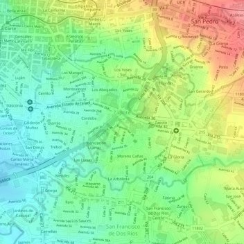
Name: Zapote topographic map, elevation, terrain.
Location: Zapote, Cantón San José, San Jose Province, 10105, Costa Rica (9.91276 -84.07168 9.92792 -84.04680)
Average elevation: 1,172 m
Minimum elevation: 1,134 m
Maximum elevation: 1,224 m
Thank you for supporting this site ❤️
Make a donation
Make a donation
Other topographic maps
Click on a map to view its topography, its elevation and its terrain.