
Thank you for supporting this site ❤️
Make a donation
Make a donation
Hawaiʻi County topographic map
Click on the map to display elevation.
Thank you for supporting this site ❤️
Make a donation
Make a donation
About this map
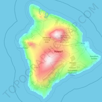
Name: Hawaiʻi County topographic map, elevation, terrain.
Location: Hawaiʻi County, Hawaii, United States (18.86546 -156.12000 20.32145 -154.75579)
Average elevation: 476 m
Minimum elevation: 0 m
Maximum elevation: 4,173 m
Thank you for supporting this site ❤️
Make a donation
Make a donation
Other topographic maps
Click on a map to view its topography, its elevation and its terrain.