
Thank you for supporting this site ❤️
Make a donation
Make a donation
Tabuelan topographic map
Click on the map to display elevation.
Thank you for supporting this site ❤️
Make a donation
Make a donation
About this map
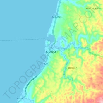
Name: Tabuelan topographic map, elevation, terrain.
Location: Tabuelan, Cebu, Central Visayas, 6044, Philippines (10.78288 123.83235 10.86288 123.91235)
Average elevation: 45 m
Minimum elevation: -2 m
Maximum elevation: 200 m
Thank you for supporting this site ❤️
Make a donation
Make a donation
Other topographic maps
Click on a map to view its topography, its elevation and its terrain.