
Make a donation
Forestville topographic map
Click on the map to display elevation.
Make a donation
About this map
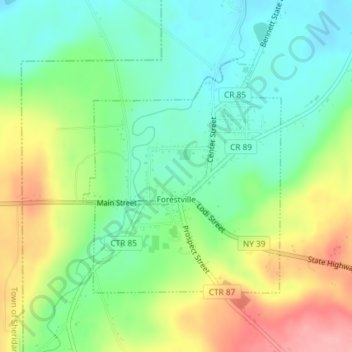
Name: Forestville topographic map, elevation, terrain.
Average elevation: 298 m
Minimum elevation: 252 m
Maximum elevation: 372 m
Make a donation
Other topographic maps
Click on a map to view its topography, its elevation and its terrain.
Van Buren Point
United States > New York > Chautauqua County > Town of Portland
Average elevation: 177 m
Irving
United States > New York > Chautauqua County
Irving is a hamlet in Chautauqua County, New York, United States. (It also falls in Cattaraugus County and Erie County. The Cattaraugus County part of Irving is part of the Seneca Nation Native American territory, the Erie County part borders Brant, New York and also is part of the Seneca Nation territory. )…
Average elevation: 185 m
Findley Lake
United States > New York > Chautauqua County
Findley Lake is part of the town of Mina in southwestern Chautauqua County, New York, United States. Situated at an elevation of 1440 ft (439 m) above sea level, this hamlet is located on the north shore of Findley Lake.
Average elevation: 463 m
Make a donation
Dewittville
United States > New York > Chautauqua County > Town of Chautauqua
Average elevation: 425 m
Conewango Valley
United States > New York > Chautauqua County > Town of Ellington
Average elevation: 409 m
Make a donation
Make a donation