
Make a donation
Erigavo topographic map
Click on the map to display elevation.
Make a donation
Erigavo
10 kilometres or 6.2 miles to the north of the town are remnant juniper woodlands that form part of the northern escarpment forests fringing the Sanaag highlands, within the Somali montane xeric woodlands ecoregion. The escarpment forms a sharp drop to the Gulf of Aden coastal plain, reaching around 2,000 metres or 6,560 feet in elevation before descending toward the coast, a pattern typical of the northern ranges where upland catchments drain to the Gulf. 2 kilometres or 1.2 miles to the west, the massif rises to Shimbiris (Mount Shimbiris), the highest point in Somaliland at about 2,460 metres or 8,070 feet above sea level. A road from Erigavo also leads onto the Daallo plateau/Daallo escarpment, part of a long-recognized forest belt; the Daallo Important Bird Area supports evergreen forest dominated by Juniperus procera and Olea on the rocky scarp. The nearby ancient coastal settlement of Heis (Xiis) has been the subject of recent archaeological missions documenting its role in Red Sea trade networks.
Make a donation
About this map
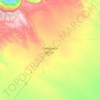
Name: Erigavo topographic map, elevation, terrain.
Location: Erigavo, Erigavo District, Sanaag, Somaliland, Somalia (10.45806 47.21000 10.77806 47.53000)
Average elevation: 1,774 m
Minimum elevation: 1,193 m
Maximum elevation: 2,446 m
Make a donation
Other topographic maps
Click on a map to view its topography, its elevation and its terrain.