
Peshāwar District topographic map
Interactive map
Click on the map to display elevation.
About this map
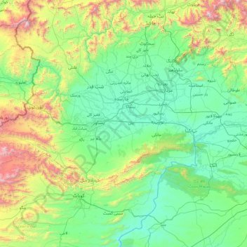
Name: Peshāwar District topographic map, elevation, terrain.
Location: Peshāwar District, Khyber Pakhtunkhwa, Pakistan (33.36000 71.11000 34.64000 72.39000)
Average elevation: 645 m
Minimum elevation: 223 m
Maximum elevation: 2,722 m
Other topographic maps
Click on a map to view its topography, its elevation and its terrain.
Mathra
Pakistan > Khyber Pakhtunkhwa > Peshawar District
Mathra, Mathra Tehsil, Peshawar District, Peshawar Division, Khyber Pakhtunkhwa, Pakistan
Average elevation: 330 m
Mohmand Agency
Mohmand Agency, Khyber Pakhtunkhwa, Pakistan
Average elevation: 1,237 m
Istor-o-Nal
Istor-o-Nal, Chitrāl District, Khyber Pakhtunkhwa, Pakistan
Average elevation: 6,853 m
Tirich Mir
Tirich Mir, Chitrāl District, Khyber Pakhtunkhwa, Pakistan
Average elevation: 6,886 m
Chitral
Pakistan > Khyber Pakhtunkhwa > Chitral
Chitral, Chitrāl District, Khyber Pakhtunkhwa, Pakistan
Average elevation: 2,047 m
Saraghrar I
Saraghrar I, Chitrāl District, Khyber Pakhtunkhwa, Pakistan
Average elevation: 6,780 m
Abbottabad
Pakistan > Khyber Pakhtunkhwa > Abbottabad
Abbottabad, Abbottābād District, Khyber Pakhtunkhwa, 22010, Pakistan
Average elevation: 1,365 m
Khyber Pakhtunkhwa
Khyber Pakhtunkhwa, Pakistan
Average elevation: 2,135 m