
Thank you for supporting this site ❤️
Make a donation
Make a donation
Tillsonburg topographic map
Click on the map to display elevation.
Thank you for supporting this site ❤️
Make a donation
Make a donation
About this map
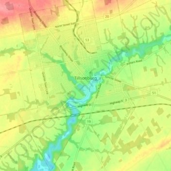
Name: Tillsonburg topographic map, elevation, terrain.
Location: Tillsonburg, Oxford County, Ontario, Canada (42.82395 -80.76183 42.88910 -80.70044)
Average elevation: 239 m
Minimum elevation: 197 m
Maximum elevation: 282 m
Thank you for supporting this site ❤️
Make a donation
Make a donation
Other topographic maps
Click on a map to view its topography, its elevation and its terrain.
Thank you for supporting this site ❤️
Make a donation
Make a donation
Thank you for supporting this site ❤️
Make a donation
Make a donation
Thank you for supporting this site ❤️
Make a donation
Make a donation