
Thank you for supporting this site ❤️
Make a donation
Make a donation
Orange Walk topographic map
Click on the map to display elevation.
Thank you for supporting this site ❤️
Make a donation
Make a donation
About this map
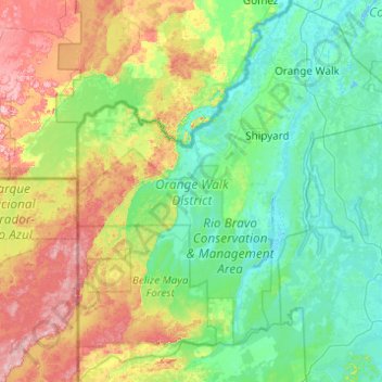
Name: Orange Walk topographic map, elevation, terrain.
Location: Orange Walk, Belize (17.31579 -89.15196 18.24522 -88.28730)
Average elevation: 77 m
Minimum elevation: -2 m
Maximum elevation: 325 m
Thank you for supporting this site ❤️
Make a donation
Make a donation
Other topographic maps
Click on a map to view its topography, its elevation and its terrain.