
Thank you for supporting this site ❤️
Make a donation
Make a donation
Tangoio topographic map
Click on the map to display elevation.
Thank you for supporting this site ❤️
Make a donation
Make a donation
About this map
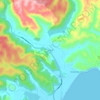
Name: Tangoio topographic map, elevation, terrain.
Location: Tangoio, Hastings District, Hawke's Bay, New Zealand (-39.34797 176.88728 -39.30797 176.92728)
Average elevation: 80 m
Minimum elevation: 0 m
Maximum elevation: 252 m
Hastings District trails, hiking, mountain biking, running and outdoor activities
Thank you for supporting this site ❤️
Make a donation
Make a donation
Other topographic maps
Click on a map to view its topography, its elevation and its terrain.
Thank you for supporting this site ❤️
Make a donation
Make a donation
Thank you for supporting this site ❤️
Make a donation
Make a donation